Thursday, August 12, 2010

Hawaii and the future


The submersed, volcanically inactive islands of the northwest part of the volcanic archipelago of volcanic islands of which the state of Hawai'i is a part, points to the future of the present Hawaiian islands.

As the Pacific Plate continues its cm-by-cm journey to the northwest, the Big Island of Hawai'i will move off the hot spot, its volcanic activity will cease, and erosion will eventually reduce the island to a submersed shadow of its former self.

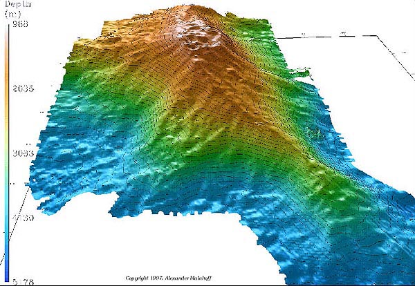
This rather bleak view of Hawai'i’s future is tempered with the knowledge that even as erosion claims the older islands, and eventually the big island, even now the next island in the chain is growing on the seafloor off the southeast coast of Hawaii. Loihi is the name already given to this next piece of real estate in the Hawaiian chain.

Image of Loihi from here.

Wednesday, August 11, 2010

Hawaii and hot spots


The Hawai'i archipelago is the product of the interplay of plate tectonics—the shifting of the Earth’s outer, rigid crust—with a plume of molten material welling up from the Earth’s mantle, a hotspot.

The Hawaiian islands formed sequentially as the Pacific plate moved to the northwest over this hotspot. The upwelling magma erupted as basaltic flows on the ocean floor that eventually built up thousands of feet to breach the surface and form an island.

As the Pacific plate continued its movement to the northwest, the new island moved off the hot spot, and volcanic activity ceased. Once volcanic activity ceased, no new rock was added to the island, and surface processes, the action of wind and waves, became the dominant processes in shaping the island, and the quieted volcanic island began to succumb to erosion, eventually disappearing beneath the waves.

Photo: the southern coast of the Big Island takes a pounding from the waves.


Tuesday, August 10, 2010

More Aloha


The islands that comprise the state of Hawai’i are part of an extensive archipelago of volcanic islands—most of them well below sea level and most of them dormant---that stretches from the Big Island of Hawaii north and west to the Aleution Islands, another volcanic archipelago that stretches westward from Alaska to Asia.

Radiometric dates of basalts show that Hawaii’s islands grow older to the northwest; the big Island, the southernmost island in the chain, is the youngest (and indeed is still growing through active volcanic flows).

The Big Island is also the largest of the islands, thus it’s name, and the older islands are smaller.

The Big Island is the only currently volcanically active island; the older islands are not.

These three different lines of observation led geologists to formulate the hot spot theory.

Illustration from here.

Monday, August 9, 2010

Hawai’i Volcanoes National Park


Most national parks and monuments preserve the story of the park’s geological past—past climates, past tectonic history. At Hawai’i Volcanoes National Park on the Big Island of Hawai’i, Hawai’i’s past, present, and future is written in basalt—the cooled basalt that comprises the island and the still-molten basalt flows that snake their way to the ocean on the islands’ south-east shore.

The Big Island of Hawai'i is the southernmost island in the archipelago that comprises the islands in the state of Hawaii but that extends northwestward as a submersed chain of seamounts to the Aleutian archipelago of Alaska. The Big Island of Hawaii is the largest island and the only one in the chain still volcanically active.

See Google maps image to trace the Hawaiian island chain.

The US Geological Survey maintains the best site for Hawaiian volcanic activity.

Photo: night viewing of active basalt flows, Kilauea volcano on the Big Island.

Saturday, August 7, 2010

Hawai'i on a budget


If you can’t make it to Hawaii to see the effects of basaltic volcanism you might plan a visit to Craters of the Moon National Monument in Central Idaho.

The barren landscape that gives the name to the area is the result of volcanic activity 15,000-2000 years ago, and was shaped by forces similar to those that shaped the Hawaiian islands.

Craters of the Moon is a part of what is called the Great Rift volcanic zone, a 50-mile-long corridor encompassing an area roughly the size of the state of Rhode Island. The area includes 60 lava flows and 25 volcanic cones.

A rift zone is an area where the Earth’s crust is being pulled apart, allowing magma to well up from below. The cause of the rifting is still a matter of study, but, as with the basalt eruptions of Hawaii, the cause may be a hot spot in the mantle beneath the North American continent.

P.S. In 1969 Apollo 14 astronauts Alan Shepard, Edgar Mitchell, Joe Engle and Eugene Cernan visited Craters of the Moon. They explored the lava landscape in order to learn the basics of volcanic geology in preparation for future trips to the moon.

P.P.S. “The Devil's Vomit" is how one pioneer described Craters of the Moon. In the 1850's and 1860's hundreds of pioneers traveled through the area along the Oregon trail.

Photo from the National Parks Service

Friday, August 6, 2010

Oregon's trail through time


In North-Central Oregon, the John Day Fossil Beds record a succession of ecosystems over 57 million years from lush tropical jungle with crocodiles and palm trees to cooler and drier forests and grassland inhabited by horses and camels.

The dramatically shifting landscape evolved as tectonic plate collision along the nearby North American plate boundary gave rise to volcanic mountains along the west coast.

Some of the sedimentary layers at John Day are the deposits of massive mudflows generated by volcanic eruptions that engulfed entire forests. Other beds resemble those at Florissant in Wyoming—fossil lake deposits preserving fish, leaves, and insects.

Like Idaho’s Hagerman fossil beds, the youngest John Day beds preserve a pre-ice-age fauna, and the painted hills of the John Day beds recall the deeply weathered deposits of South Dakota’s Badlands.

Learn more about the John Day fossil beds here.

Illustration of the stratigraphic sequence is from here.

http://www.nps.gov/joda/naturescience/geologicformations.htm

Thursday, August 5, 2010

Idaho's fossil horse


In an area of south-central Idaho, bounded on the east by the Snake River and on the south by the Oregon trail, the 3-4 million year old sedimentary rocks of the Hagerman fossil beds preserve the largest concentrations of fossil horses in North America, in addition to over 200 species of plants and animals, including bear, otter, camel, sabertooth cat, and even a mole.

These rocks preserve a slice of time before the last Ice Age. Today, the area receives less than 10 inches of rainfall; the fossils give evidence that the climate in which these animals lived was much wetter.

The site is named for a species of fossil horse, Equus simplicidens, found in abundance near Hagerman, Idaho. It is the state fossil of Idaho, and the oldest known example Equus, the genus that includes modern horses, donkeys, and zebras.

P.S. The Hagerman horse was chosen for the theme of the "Idaho" U-Haul graphic.

More information on the Hagerman Fossil Beds here.

The illustration is an artist's reconstruction of the Hagerman ecosystem during the Pliocene Epoch. The original painting is at the Smithsonian Institution.

Wednesday, August 4, 2010

Colorado’s fossil redwood forest


34 million years ago, in central Colorado, volcanic eruptions sent mudflows downslope, burying a forest of giant redwoods, damming a nearby river, and forming a large lake.

Subsequent eruptions deposited volcanic ash that buried insects and plants washed into the lake. The fine-grained ash preserved the smallest detail, including the antennae, legs, and sensory hairs of insects and the petals of flowers. This story is preserved in the rocks of Florissant Fossil Beds National Monument.

Florissant is famous for its abundance of fossil leaves, large tree stumps, and insects. More than 1,500 different kinds of fossil insects are found here, including dragonflies, cockroaches, grasshoppers, flies, beetles, wasps, ants and butterflies. The largest fossil tree preserved at Florissant is 13 feet in diameter and estimated to have been 300 feet tall and 1,000 years old.

A fossil photo gallery can be found here.

The image, above is from here.

Tuesday, August 3, 2010

Wyoming's fossil lake


50 million years ago, during the Eocene Epoch of the Cenozoic Era, a sub-tropical lake covered a portion of what is now southwestern Wyoming.

Fossil Butte National Monument preserves in its finely layered sedimentary rocks a window into the aquatic and nearby terrestrial ecosystems of this time. The deposits are famous for the diversity and abundance of its fossil fish, and other fossils include reptiles, birds, insects, plants, and the oldest known fossil bat.

Preservation of these fossils is exquisite, suggesting that conditions at the bottom of the lake were toxic, and excluded the scavengers and decomposers that otherwise would have destroyed these remains.

Workers building the Union Pacific railroad in the late 1860’s discovered the fossil fish beds near the town of Green River, Wyoming, and geologists refer to these fossil-bearing strata as the Green River Formation.

More information from the National Parks Service, here.

http://www.nps.gov/fobu/naturescience/naturalfeaturesandecosystems.htm

Monday, August 2, 2010

Dinosaur National Monument


In 1909 Earl Douglass, a vertebrate paleontologist from the Carnegie Museum of Pittsburgh, Pennsylvania, mounted an expedition to northeastern Utah to prospect for dinosaurs for his Museum.

Douglass chose his prospecting site carefully, knowing that dinosaurs were likely to be found in the preserved sediments of ancient river systems. The expedition was a resounding success, and in 1915 President Woodrow Wilson proclaimed the Douglass quarry Dinosaur National Monument.

The Monument preserves the remains of more than 1500 fossil bones in place in the sandstone in which they were preserved. Thanks to tectonics, the originally flat-lying sedimentary rock layers were tilted upwards so that the fossil bone bed forms a wall of the visitor’s center, a kind of paleontological bas relief.

More information from the National Parks Service here.