Friday, October 22, 2010

Energy tradeoffs


There is no one easy solution to meeting the energy needs of the 21st century and beyond; every technology has its trade-offs:
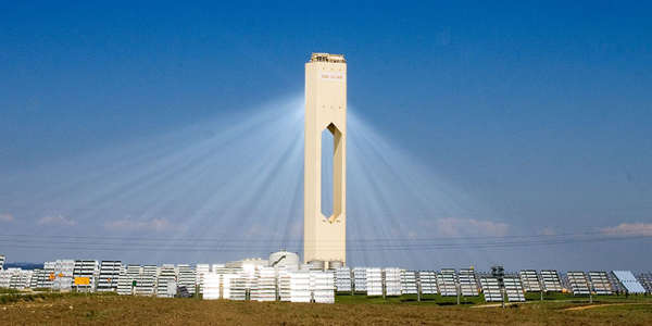
Petroleum and coal are both non-renewable and produce greenhouse gases; solar and wind energy both require lots of land and the energy collected from them can not yet be efficiently distributed; and hazardous waste from nuclear power plants must be dealt with for thousands of years.
Less obvious are the hidden costs of energy sources; biofuels, regarded as the “greenest” technology, uses hundred of liters of water to grow the fuel.
The other side of the energy equation is reducing use, which is an issue that involves education and public policy. The solution to our future energy needs requires the input from scientists, engineers, educators, policy makers, and you.
Science magazine has a special section on scaling up alternative energies and the trade-offs involved.
[Adrian Cho, Science, v. 329, 13 August 2010,p. 786-787]
Image from here.

Thursday, October 21, 2010

Geothermal energy, revisited


Volcanoes and geysers bear witness to the enormous reservoir of energy--in the form of heat--that lies in the earth's interior. This geothermal energy can be used to generate electricity wherever there is a source of heat close to the earth's surface. Unlike the non-renewable fossil fuels, geothermal energy will last until the earth's internal engine runs out of fuel, millions of years from now.

But geothermal energy has its limitations as an alternative energy source. Production of geothermal energy is limited to relatively few areas with the required local geothermal source, and drilling to tap these sources can have unintended consequences. A geothermal project in Switzerland was canceled in 2007 after drilling caused a magnitude 3.4 earth tremor.

Source: E. Kintisch, Science 329:789, 13 Aug. 2010

Photo from here, along with a list of "Top 10 alternative energy sources"

Wednesday, October 20, 2010

Ethanol and policy issues


Recently, the U.S. government increased the cap on the amount of ethanol that can be used in gasoline from 10% to 15%. Upping this limit should encourage the development of alternative sources of ethanol, but changing this limit affects the car manufacturers.

A proposal to require cars to use an E85 blend (that is, 85% ethanol, 15 % petroleum) could be accommodated by car manufacturers, but it is not known whether this ethanol-rich blend would damage engines designed to operate on the current 10% blend.

Scaling up the use of cellulosic biofuel is not just a scientific or technological issue, but a policy issue as well. One scenario would be to have the ethanol limit gradually increase from to 85%; the current increase to 15% is a down payment on this strategy.

Learn more about E85 and "flex fuel" vehicles here.

Photo: an E85-powered Chevrolet HHR.

Tuesday, October 19, 2010

Growing Green


A major roadblock to scaling up the use of cellulosic biofuel is the difficulty and expense of extracting the ethanol from these materials.

The ethanol currently used in gasoline mixtures come from fermentation of sugars present in corn kernels, and is a relatively simple and inexpensive process. However, the sugar in cornstalks and other cellulosic biofuel is locked in chemical structures that are harder to break and the ethanol yield is lower, which means that manufacturers of cellulosic ethanol require much more raw material than the ethanol manufacturers.

Scientists are exploring ways to extract cellulosic ethanol more effectively. One possible solution is to engineer new microbes that can break down cellulose into sugars that can more easily be fermented to form ethanol.

The Great Lakes Bioenergy Research Center is a consortium of organizations working to conduct this sort of "transformational biofuels research". Go Green!

Monday, October 18, 2010

Biofuels


Ethanol is a fuel derived from plant material, primarily corn kernels. Although a renewable resource, one of the down-sides of using corn-derived ethanol as fuel is that it diverts grain from food to energy use, driving up food prices. This concern was addressed by research into using biowaste, that is, grasses, cornstalks, and wood chips not used for food.

The problem with using this “cellulosic” ethanol is that the ethanol is much harder to extract. Currently, just 40% of the energy content available in cellulosic plant sources is recoverable, compared to 90% of the energy in kernal ethanol.

But another issue with ethanol from corn is that the process requires a lot of energy, and the end-product ethanol does not represent a big savings in the use of fossil fuels in the process and still contributes to greenhouse gas emissions.

More on the pros and cons of ethanol, here.

Friday, October 15, 2010

Wind energy, revisited


Wind..it’s clean, and does not produce climate-changing greenhouse gasses...

But problems associated with modern wind turbines threaten the growth of wind as an alternative energy source. Birds and bats have been killed by the spinning blades, the motion of the blades can show up on flight controller’s radar, and noise is an issue for people who live near wind turbines.

Twenty years of using modern wind technology has led to some improvements; siting wind turbines now takes into account migratory routes and roosting sites of birds and bats. Engineers are working to make the turbine blades less visible to radar and less noisy.

Ultimately, however, changing negative attitudes toward wind farms must involve more than technological fixes and include public education of the benefits and tradeoffs of wind energy technology.

Source: E. Kintisch, Science 329:788-789

Thursday, October 14, 2010

Nuclear power, revisited


Nuclear energy became anathema after nuclear plant accidents released radioactivity into the environment. But in the wake of environmental accidents due to oil spills and growing concerns about the environmental impact of burning coal, nuclear power is making a comeback.

More than 100 new nuclear power plants are planned to come online, worldwide, over the next 10 years. Lessons learned since Three-Mile Island insure that the new reactors will be safer.

Still a challenge to acceptance and wide-spread use of nuclear power is the disposal of high-level nuclear wastes (HLW), especially the spent fuel rods, which may continue to emit dangerous levels of radiation for a million years. Disposal of HLW is not just a scientific issue but a political hot potato.

Image of the atom from here.

Wednesday, October 13, 2010

National Fossil Day


The record of life on Earth is written in stone--

National Fossil Day is a celebration organized by the National Park Service to promote public awareness and stewardship of fossils, as well as to foster a greater appreciation of their scientific and educational values.
Learn more...


Tuesday, October 12, 2010


Solar power has matured as an alternative energy source over the last 20 years, but there are still obstacles to overcome before the energy from the sun can significantly supplement other sources of energy.

Collecting solar energy is only part of the process, storing it for later use is still “technically and economically challenging.”* Concentrating solar power plants, or CSPs, like the one shown here, use mirrors to focus solar radiation and generate heat that can be converted to energy, but CSPs are located where the solar radiation is most abundant year-round, which is not where most people and most of the energy demand is.

There are environmental issues, as well. Recently the California Energy Commission recommend against building a new installation in the Mohave desert because of its potential impact on turtles.

*Source: Science, 329:773, August 13, 2010, Roeb, M, and H. Muller-Steinhagen

Photo of concentrated solar power plant, and other information on solar power is available here. This structure's resemblance to Isengard is interesting...

Monday, October 11, 2010

It's Earth Science Week


If you are under the age of 30, you may not be aware that the term “energy crisis” was NOT coined during your lifetime. Your parents might remember the lines at gas stations in the late 1970s.

We find ourselves in the 21st century apparently not having learned the lessons from our earlier crises that stemmed from dependence on a non-renewable energy source—petroleum—the production and transportation of which can have profound environmental effects (two examples: Exxon Valdez and the Deep Horizon oil rig) and the combustion of which contributes to global climate change.

We have learned that our energy choices have profound geopolitical, social, and environmental consequences. The American Geological Institute designates a week in October as Earth Science Week, and this year's theme is energy.

AGI's webpage for Earth Science week is here.


Thursday, October 7, 2010

Flower Power


What would a world without flowers be like?

The dinosaurs knew the answer to that question, as they lived in an age before the evolution of angiosperms, the flowering plants.

Angiosperms are the most diverse group of land plants on Earth today, and include not only all the plants whose blooms we appreciate, like roses, but all our deciduous trees and grasses, and grains--corn, rice, and wheat.

Paleontologists have modeled the flower-less Earth scenario, and found that an Earth without flowers would not only be less colorful, but it would be hotter and drier, as the leaves from angiosperms add a significant amount of water vapor to the atmosphere through the process of transpiration.

Moisture impacts biodiversity as well, and a flower-less Earth would have fewer species of plants and animals. Angiosperms add more than just color to our lives

More information on a world without angiosperms, and a link to the original research here.

Wednesday, October 6, 2010

Melville's Whale


Modern sperm whales, the largest predators alive today, have teeth only on the lower jaw and use suction to catch their cephalopod prey.

The discovery of a new fossil species of sperm whale from rocks 15 million years old helps to fill in our understanding of the evolution of sperm whales. The newly discovered whale has jaws that have both upper and lower teeth, teeth that are 36 cm long, giving this fossil predator the biggest bite known. Based on the size of the skull, paleontologists estimate a body length of 13 to 17 meters.

Named Leviathan melvillei, for the novelist Herman Melville, author of Moby Dick, this sperm whale's appearance in the fossil record coincides with diversification of baleen whales. Leviathan melvillei probably fed on baleen whales and as a top predator, helped shape Miocene marine communities.

See summary of the Nature article and more illustrations here.


Tuesday, October 5, 2010

Warm-blooded reptiles?


Modern reptiles are cold blooded, but what about extinct reptiles?
Based on their teeth, large extinct swimming reptiles, like ichthyosaurs, plesiosaurs, and mosasaurs are thought to have been predators in the Mesozoic oceans. Their streamlined body profile also suggests an active lifestyle. An active lifestyle requires high metabolic rates, which are usually correlated with at least some ability to regulate body temperature.
Scientists analyzed oxygen isotopes from the teeth of these extinct marine reptiles and compared the values with those from cold-blooded fossil fish. The results showed ichthyosaurs and plesiosaurs differed significantly from fish, and suggest that these two reptiles, both of whom were active, "pursuit predators", probably controlled their body temperature. The data for mosasaurs were equivocal and suggest that mosasaurs led a different lifestyle perhaps as an opportunistic ambush predator.
Illustration of an ichthyosaur is from here.


Monday, October 4, 2010

The fauna that keeps on giving


The Burgess Shale of British Columbia, Canada, is famous for its exceptional preservation of bizarre, soft-bodied invertebrate lifeforms, a window into the Middle Cambrian World of 510 million years ago.

Burgess Shale-like faunas are now known from localities world-wide, but recently paleontologists discovered in Morocco a Burgess fauna from rocks 30 million years younger than the Cambrian faunas.

Burgess shale faunas were thought to have gone extinct after the Middle Cambrian. This new discovery suggests that the disappearance of the older fauna was a due to the absence of suitable conditions for fossilization rather than extinction, and it underlines the importance of understanding the conditions and processes leading to fossilization, and it opens the possibility of finding other Burgess faunas.

From P. Van Roy, P. J. Orr, J. P. Botting, L. A. Muir, Jacob Vinther, B. Lefebvre, K. el Hariri, and D. E. G. Briggs. 2010. Ordovician faunas of Burgess Shale type. Nature 465:215-218. A longer summary of their research is here. Photo of Marella, a Burgess arthropod, from the original article.

Thursday, September 30, 2010

Steno and stratigraphy


Nicholas Steno, born in 1638, was a renaissance era scholar, whose experience in comparative anatomy provided some of the earliest evidence recognizing fossils as the preserved remains of animals, which he famously demonstrated by comparing modern shark teeth to fossils shark teeth.

Steno is also credited with enunciating basic principles of geology that help determine the relative order of geological events that led to the development of a geological time scale.

Steno reasoned that sedimentary rock layers were formed when particles in a fluid such as water fell to the bottom, resulting in horizontal layers. Thus Steno's principle of original horizontality states that these rock layers form in the horizontal position.

Steno realized that tilted or folded rock layers, like the ones shown in the illustration here, meant that the layers were disturbed after they were deposited. It may seem obvious to us today, but this insight represented a huge step toward understanding 4.6 billion years of earth history.

Image and more information available here.

Wednesday, September 29, 2010

Telling time with sedimentary rock layers


Nicholas Steno is also credited with being the first to understand (and communicate to others) the most basic principle of ordering sedimentary strata, the principle of superposition, which states that in a sequence of undeformed rock strata, the oldest beds are on the bottom and the youngest are on the top. Simple, yes?


It is important to remember that this principle refers specifically to sedimentary rocks, deposited layer by layer as strata. Some metamorphic rocks may show banding that resembles layering (compare the layered gneiss show above to the sandstone), but these “layers” do not follow the principle of superposition—they reflect reorganization of grains due to stresses in the Earth’s crust associated with plate tectonics. It is sometimes difficult for aspiring geologists to tell the difference, especially in an isolated hand-sample. Familiarity with the three main types of rocks is the key to making this distinction.


The diagram, above (from here), shows how the process of superposition could happen in a lake setting.

Tuesday, September 28, 2010

Finding order among the rocks


When geologists refer to events that occurred 200 million years ago, they are referring to dates on the geological time scale that have been added since the discovery in the late 19th century of the use of radioactive decay as a tool for determining the age of geologic materials.

The geological time scale is an evolving document, and radiometric dates are subject to refinement as technology advances.

But the geological time scale has always been an evolving document, even before dates were added. The names of the geologic eras, periods, and epochs on the geologic time scale we use today were not written in stone (so to speak!) but represent the latest version of a document that has its origins in principles enunciated almost 400 years ago.

Figuring out the order in which rock layers were deposited or emplaced was the first step to developing a time scale.

Monday, September 27, 2010

What is time?


How can geologists use rocks to create a chronology of Earth history?


To address this issue we need to understand the basic measure of time.


The orbit of the Earth around the Sun measures a year, the rotation of the Earth on its axis defines a day, and the vibration of the Cesium atom in an observatory near London marks seconds, but what do these different phenomena have in common?


A year is measured by the change in the position of the Earth in its orbit relative to the sun; a day is measured by change due to Earth’s rotation, and a second is measured by the change in position of a vibrating atom. Change is the fundamental measure of time.


Changes are recorded in rocks, for example, the layers of sedimentary rock record periods of deposition alternating with periods of non-deposition; metamorphic rocks record change from a previous non-metamorphosed state, igneous rocks record the change of cooling from a molten state to a crystalline state. So it’s valid to use rocks as geochronometers in sorting out the history of the Earth.


The "spiral of time" graphic (a classic!) can be found here, along with more information.

Tuesday, September 7, 2010

Stories pebbles tell


From their first discovery, fossils had been interpreted as stones that fell from the sky, tricks of the devil, or objects that grew in the rocks in which they are found.


Nicholas Steno’s work with modern shark teeth convinced him that the objects we recognize as fossil shark teeth looked like shark teeth because they were shark teeth, and that they must have been buried in mud or that was now dry land.


Steno also reasoned that if the fossil were a structure that had grown within solid rock, its shape would have been distorted by the enclosing rock. The pristine condition of the fossil shark teeth indicated instead that the tooth must have been buried in soft sediments which hardened later.


Steno’s realization that objects entombed within rock, like fossils or pebbles in a conglomerate were formed before the rock itself was deposited. This was another way to distinguish the relative order of events and is called the principle of included fragments.


Simply put, this principle states that the included fragment (be it a fossil in limestone or a rounded pebble in a conglomerate, shown above) is older than the rock that encloses it.


Image and more information available here.

Thursday, August 12, 2010

Hawaii and the future


The submersed, volcanically inactive islands of the northwest part of the volcanic archipelago of volcanic islands of which the state of Hawai'i is a part, points to the future of the present Hawaiian islands.

As the Pacific Plate continues its cm-by-cm journey to the northwest, the Big Island of Hawai'i will move off the hot spot, its volcanic activity will cease, and erosion will eventually reduce the island to a submersed shadow of its former self.

This rather bleak view of Hawai'i’s future is tempered with the knowledge that even as erosion claims the older islands, and eventually the big island, even now the next island in the chain is growing on the seafloor off the southeast coast of Hawaii. Loihi is the name already given to this next piece of real estate in the Hawaiian chain.

Image of Loihi from here.

Wednesday, August 11, 2010

Hawaii and hot spots


The Hawai'i archipelago is the product of the interplay of plate tectonics—the shifting of the Earth’s outer, rigid crust—with a plume of molten material welling up from the Earth’s mantle, a hotspot.

The Hawaiian islands formed sequentially as the Pacific plate moved to the northwest over this hotspot. The upwelling magma erupted as basaltic flows on the ocean floor that eventually built up thousands of feet to breach the surface and form an island.

As the Pacific plate continued its movement to the northwest, the new island moved off the hot spot, and volcanic activity ceased. Once volcanic activity ceased, no new rock was added to the island, and surface processes, the action of wind and waves, became the dominant processes in shaping the island, and the quieted volcanic island began to succumb to erosion, eventually disappearing beneath the waves.

Photo: the southern coast of the Big Island takes a pounding from the waves.


Tuesday, August 10, 2010

More Aloha


The islands that comprise the state of Hawai’i are part of an extensive archipelago of volcanic islands—most of them well below sea level and most of them dormant---that stretches from the Big Island of Hawaii north and west to the Aleution Islands, another volcanic archipelago that stretches westward from Alaska to Asia.

Radiometric dates of basalts show that Hawaii’s islands grow older to the northwest; the big Island, the southernmost island in the chain, is the youngest (and indeed is still growing through active volcanic flows).

The Big Island is also the largest of the islands, thus it’s name, and the older islands are smaller.

The Big Island is the only currently volcanically active island; the older islands are not.

These three different lines of observation led geologists to formulate the hot spot theory.

Illustration from here.

Monday, August 9, 2010

Hawai’i Volcanoes National Park


Most national parks and monuments preserve the story of the park’s geological past—past climates, past tectonic history. At Hawai’i Volcanoes National Park on the Big Island of Hawai’i, Hawai’i’s past, present, and future is written in basalt—the cooled basalt that comprises the island and the still-molten basalt flows that snake their way to the ocean on the islands’ south-east shore.

The Big Island of Hawai'i is the southernmost island in the archipelago that comprises the islands in the state of Hawaii but that extends northwestward as a submersed chain of seamounts to the Aleutian archipelago of Alaska. The Big Island of Hawaii is the largest island and the only one in the chain still volcanically active.

See Google maps image to trace the Hawaiian island chain.

The US Geological Survey maintains the best site for Hawaiian volcanic activity.

Photo: night viewing of active basalt flows, Kilauea volcano on the Big Island.

Saturday, August 7, 2010

Hawai'i on a budget


If you can’t make it to Hawaii to see the effects of basaltic volcanism you might plan a visit to Craters of the Moon National Monument in Central Idaho.

The barren landscape that gives the name to the area is the result of volcanic activity 15,000-2000 years ago, and was shaped by forces similar to those that shaped the Hawaiian islands.

Craters of the Moon is a part of what is called the Great Rift volcanic zone, a 50-mile-long corridor encompassing an area roughly the size of the state of Rhode Island. The area includes 60 lava flows and 25 volcanic cones.

A rift zone is an area where the Earth’s crust is being pulled apart, allowing magma to well up from below. The cause of the rifting is still a matter of study, but, as with the basalt eruptions of Hawaii, the cause may be a hot spot in the mantle beneath the North American continent.

P.S. In 1969 Apollo 14 astronauts Alan Shepard, Edgar Mitchell, Joe Engle and Eugene Cernan visited Craters of the Moon. They explored the lava landscape in order to learn the basics of volcanic geology in preparation for future trips to the moon.

P.P.S. “The Devil's Vomit" is how one pioneer described Craters of the Moon. In the 1850's and 1860's hundreds of pioneers traveled through the area along the Oregon trail.

Photo from the National Parks Service

Friday, August 6, 2010

Oregon's trail through time


In North-Central Oregon, the John Day Fossil Beds record a succession of ecosystems over 57 million years from lush tropical jungle with crocodiles and palm trees to cooler and drier forests and grassland inhabited by horses and camels.

The dramatically shifting landscape evolved as tectonic plate collision along the nearby North American plate boundary gave rise to volcanic mountains along the west coast.

Some of the sedimentary layers at John Day are the deposits of massive mudflows generated by volcanic eruptions that engulfed entire forests. Other beds resemble those at Florissant in Wyoming—fossil lake deposits preserving fish, leaves, and insects.

Like Idaho’s Hagerman fossil beds, the youngest John Day beds preserve a pre-ice-age fauna, and the painted hills of the John Day beds recall the deeply weathered deposits of South Dakota’s Badlands.

Learn more about the John Day fossil beds here.

Illustration of the stratigraphic sequence is from here.

http://www.nps.gov/joda/naturescience/geologicformations.htm

Thursday, August 5, 2010

Idaho's fossil horse


In an area of south-central Idaho, bounded on the east by the Snake River and on the south by the Oregon trail, the 3-4 million year old sedimentary rocks of the Hagerman fossil beds preserve the largest concentrations of fossil horses in North America, in addition to over 200 species of plants and animals, including bear, otter, camel, sabertooth cat, and even a mole.

These rocks preserve a slice of time before the last Ice Age. Today, the area receives less than 10 inches of rainfall; the fossils give evidence that the climate in which these animals lived was much wetter.

The site is named for a species of fossil horse, Equus simplicidens, found in abundance near Hagerman, Idaho. It is the state fossil of Idaho, and the oldest known example Equus, the genus that includes modern horses, donkeys, and zebras.

P.S. The Hagerman horse was chosen for the theme of the "Idaho" U-Haul graphic.

More information on the Hagerman Fossil Beds here.

The illustration is an artist's reconstruction of the Hagerman ecosystem during the Pliocene Epoch. The original painting is at the Smithsonian Institution.

Wednesday, August 4, 2010

Colorado’s fossil redwood forest


34 million years ago, in central Colorado, volcanic eruptions sent mudflows downslope, burying a forest of giant redwoods, damming a nearby river, and forming a large lake.

Subsequent eruptions deposited volcanic ash that buried insects and plants washed into the lake. The fine-grained ash preserved the smallest detail, including the antennae, legs, and sensory hairs of insects and the petals of flowers. This story is preserved in the rocks of Florissant Fossil Beds National Monument.

Florissant is famous for its abundance of fossil leaves, large tree stumps, and insects. More than 1,500 different kinds of fossil insects are found here, including dragonflies, cockroaches, grasshoppers, flies, beetles, wasps, ants and butterflies. The largest fossil tree preserved at Florissant is 13 feet in diameter and estimated to have been 300 feet tall and 1,000 years old.

A fossil photo gallery can be found here.

The image, above is from here.

Tuesday, August 3, 2010

Wyoming's fossil lake


50 million years ago, during the Eocene Epoch of the Cenozoic Era, a sub-tropical lake covered a portion of what is now southwestern Wyoming.

Fossil Butte National Monument preserves in its finely layered sedimentary rocks a window into the aquatic and nearby terrestrial ecosystems of this time. The deposits are famous for the diversity and abundance of its fossil fish, and other fossils include reptiles, birds, insects, plants, and the oldest known fossil bat.

Preservation of these fossils is exquisite, suggesting that conditions at the bottom of the lake were toxic, and excluded the scavengers and decomposers that otherwise would have destroyed these remains.

Workers building the Union Pacific railroad in the late 1860’s discovered the fossil fish beds near the town of Green River, Wyoming, and geologists refer to these fossil-bearing strata as the Green River Formation.

More information from the National Parks Service, here.

http://www.nps.gov/fobu/naturescience/naturalfeaturesandecosystems.htm

Monday, August 2, 2010

Dinosaur National Monument


In 1909 Earl Douglass, a vertebrate paleontologist from the Carnegie Museum of Pittsburgh, Pennsylvania, mounted an expedition to northeastern Utah to prospect for dinosaurs for his Museum.

Douglass chose his prospecting site carefully, knowing that dinosaurs were likely to be found in the preserved sediments of ancient river systems. The expedition was a resounding success, and in 1915 President Woodrow Wilson proclaimed the Douglass quarry Dinosaur National Monument.

The Monument preserves the remains of more than 1500 fossil bones in place in the sandstone in which they were preserved. Thanks to tectonics, the originally flat-lying sedimentary rock layers were tilted upwards so that the fossil bone bed forms a wall of the visitor’s center, a kind of paleontological bas relief.

More information from the National Parks Service here.


Friday, July 30, 2010

White Sands


To most people the word sand means the stuff that beaches and deserts are covered with and to many of us that means sand-sized grains of the mineral quartz, the most resistant mineral at the Earth’s surface.

Quartz is insoluble and slow to weather, and so it is the stuff of many deserts and beaches. However, in a desert where the little water that falls every year creates temporary lakes, as those lakes evaporate, the minerals dissolved in the water precipitate, forming crystals of evaporite minerals like salt and gypsum.

As the winds whip across these dried up lakebeds, the crystals are swept up and piled into great glistening dunes of white gypsum sand. This is White Sands National Monument in New Mexico.

Photo from here.

More info on the park here.


Thursday, July 29, 2010

Carlsbad Caverns


The desert that surrounds Carlsbad Caverns National Park in southeastern New Mexico is not an environment conducive to cave formation and cannot account for the over 100 caves dissolved from the areas’ limestone bedrock; most of the cave formation in this area took place during the last ice age when the climate here was wetter and pine forests covered the landscape above the cave.

Unlike Mammoth Cave, which was formed by slightly acidic groundwater percolating down from the surface dissolving and enlarging fractures, at Carlsbad Caverns water enriched with hydrogen-sulfide from oil and gas deposits buried in sedimentary layers beneath the limestone migrated up from below and mixed with rainwater to form sulfuric acid, dissolving the rock and but leaving behind delicate cave deposits made of gypsum.

More information on Carlsbad from the National Parks Service.

http://www.nps.gov/cave/naturescience/cave.htm

Wednesday, July 28, 2010


Beneath the rolling hills of south-central Kentucky, subterranean chambers coalesce over 400 square miles to form the largest cave system in the world, the aptly named Mammoth Cave.

The vastness of Mammoth Cave belies its formation by literally one drop of water at a time.

Groundwater percolating through the fractured limestone bedrock dissolves the rock a molecule at a time, slowly enlarging the fractures.

Once a cave is formed, as mineral-laden groundwater drips down from the roof of the cave, crystals of calcium carbonate precipitate out and adhere to the cave roof—the beginning of a stalactite, icicle-like formations that hold tight to the ceiling. On the cave floor beneath the dripping water, calcium carbonate crystals may accumulate in a stalagmite; remember it just might reach the cave roof.

More info on Mammoth Cave National park here.

Photo from here.